The Unseen Fires
Volcanic systems represent immense, complex geological engines driven by the ascent of molten rock from the mantle. Magmatic intrusion and dike propagation often precede an eruption by months or even years, providing a crucial forecasting window. Modern volcanology has moved beyond simply cataloging events to actively interpreting these subsurface processes.
Contemporary research focuses on integrating diverse monitoring datasets to create a coherent picture of a volcano's unrest state. This holistic approach views the volcanic edifice as a dynamically pressurized system. The ultimate goal is to move from empirical pattern recognition towards physics-based forecasting.
Deciphering Magma's Precursory Signals
Forecasting eruptions depends on detecting and interpreting signals generated by magma movement. These signals manifest as measurable changes in geophysical and geochemical parameters. Accurate interpretation requires understanding the source mechanism of each anomaly.
Magma migration typically generates a suite of interrelated signals rather than a single diagnostic change. The sequence and intensity of these signals can hint at the magma's composition, ascent rate, and potential eruption style. Consequently, a multi-parameter monitoring network is non-negotiable for reliable hazard assessment at any active volcano.
A significant challenge lies in distinguishing between magmatic intrusions that will culminate in an eruption and those that will stall and crystallize at depth. This dilemma, known as the "failed eruption" scenario, is a primary focus of current research. Advanced modeling that couples magma dynamics with crustal rock mechanics is essential to quantify the likelihood of an intrusion reaching the surface.
Key measurable parameters that indicate magmatic unrest include:
- Increased and localized seismic activity, including specific tremor signatures.
- Changes in the ratio and flux of volcanic gas species like SO2 and CO2.
- Ground deformation measured by GPS, InSAR, and tiltmeters.
- Transient thermal anomalies detected by satellite-based infrared sensors.
Ground Deformation and Earthquake Swarms
The Earth's surface inflates and deflates like a breathing organism as magma accumulates or moves at depth. This ground deformation is a priimary and quantifiable precursor, measured with sub-centimeter precision.
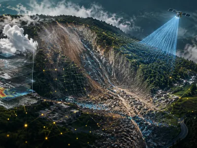
Satellite-based Interferometric Synthetic Aperture Radar (InSAR) now provides continuous, wide-area surveillance of surface strain, revealing patterns of uplift and subsidence that are invisible to the naked eye. These deformation patterns are inverted through complex models to estimate the location, depth, and volume of the intruding magma body.
Concurrently, seismicity provides a critical auditory window into the fracturing and fluid movement within the volcanic edifice. Distinguishing between tectonic earthquakes and volcanic seismicity—such as high-frequency brittle-failure events, long-period earthquakes indicative of fluid resonance, and the continuous ground vibration of harmonic tremor—is fundamental. The spatial and temporal evolution of an earthquake swarm, often migrating upwards or laterally, can track the dike propagation path in near-real-time, offering one of the most direct indicators of imminent eruptive potential.
Gaseous Messengers from the Deep
Volcanic gases are the first mobile phase to escape from ascending magma. Changes in their composition and emission rate provide an early warning of new magma arrival at shallow depths. Carbon dioxide (CO₂), being less soluble, exsolves at great depth and may signal deep intrusion.
Sulfur dioxide (SO₂) is a key species monitored by both ground-based and satellite spectrometers. A sharp increase in SO₂ flux often indicates the arrival of fresh, gas-rich magma closer to the surface.
The molar ratios of different gas species, particularly CO₂/SO₂ and SO₂/H₂S, are more diagnostic than individual gas fluxes alone. These ratios change according to pressure, temperature, and magma chemistry, acting as a geochemical thermometer and barometer. A declining CO₂/SO₂ ratio, for instance, suggests magma degassing at progressively shallower levels. Continuous multi-gas sensing stations are revolutionizing this field, moving from sporadic measurements to real-time data streams. Geochemical monitoring thus provides a direct geochemical fingerprint of subsurface magmatic processes.
Integrating Data into Predictive Models
The true predictive power in modern volcanology emerges from the data fusion of disparate monitoring streams. No single parameter is infallible; thus, integrating seismic, deformation, gas, and thermal data into probabilistic forecasting models is essential. These models assess the likelihood of various outcomes, from quiescence to eruption.
Machine learning algorithms are increasingly deployed to identify complex, non-linear patterns within large, multivariate datasets that may elude traditional analysis. These tchniques can uncover subtle precursors and improve the lead time for alerts. The transition from deterministic to probabilistic frameworks represents a paradigm shift, explicitly communicating uncertainty to decision-makers.
A critical step in model integration is the establishment of a baseline or background activity level for each volcano. This context allows for the accurate identification of significant anomalies. The table below summarizes the core data types and their primary forecasting significance.
| Data Type | Measured Parameter | Forecasting Insight |
|---|---|---|
| Seismic | Event rate, location, type (VT, LP, Tremor) | Magma fracture, fluid movement, and ascent dynamics. |
| Geodetic | Surface displacement (InSAR, GPS, tilt) | Location, volume, and pressure change of magma reservoir. |
| Geochemical | Gas flux (SO₂, CO₂) and species ratios | Magma degassing depth, composition, and ascent. |
| Thermal | Radiant heat flux (satellite IR) | Near-surface magmatic activity or vent heating. |
Implementing these models in operational settings requires robust, real-time data telemetry and computational infrastructure. The integration of multi-parameter data into physics-based models is the cornerstone of reliable volcanic hazard assessment.
Societal Resilience and Future Frontiers
Accurate scientific forecasting is ultimately meaningless without effective communication and preparedness. The complex interplay between volcanic risk perception, public policy, and emergency management defines a community's resilience. Scientific uncertainties must be transparently conveyed to avoid false alarms or complacency.
Future advancements depend on overcoming key technical and conceptual challenges. Dense, real-time sensor networks coupled with automated data assimilation will provide unprecedented temporal resolution. However, a major frontier lies in improving our understanding of sub-surface volcanic architecture and magma storage systems through advanced geophysical imaging and petrological studies.
Another critical avenue is the development of early warning systems for volcanic phenomena with very short precursory signals, such as phreatic explosions or lahars. These systems rely on rapid detection and automated alert dissemination. International collaboration and data sharing remain vital for studying a wide range of volcanic behaviors and improving global preparedness.
The following areas represent key frontiers for the next generation of volcanic hazard mitigation:
- High-resolution geophysical imaging of entire magmatic systems from mantle to surface.
- Advanced computational modeling that fully couples magma dynamics, rock mechanics, and fluid flow.
- Standardized, open-source platforms for real-time data integration and probabilistic hazard visualization.
- Systematic social science research to optimize hazard communication and evacuation protocols.
Persistent challenges include forecasting the exact onset time, duration, and style of an eruption. The final table contrasts the capabilities of current forecasting efforts with the aspirational goals of future research.
| Aspect | Current Forecasting Capability | Future Research Goal |
|---|---|---|
| Temporal Precision | Windows of days to months for magmatic eruptions; limited for phreatic events. | Narrowing forecasts to hours or days and developing reliable short-term warnings for all eruption styles. |
| Eruption Style & Size | Qualitative estimates based on analog volcanoes and precursor scaling. | Quantitative probabilistic estimates of explosivity index (VEI) and likely hazards (pyroclastic flow, ash fall). |
| Physical Basis | Often empirical, combining statistics with simplified physical models. | Fully physics-based simulations that replicate the observed precursory sequence from first principles. |
Continual refinement of monitoring technologies and forecasting methodologies, embedded within a robust risk governance framework, is the only sustainable path to mitigating volcanic disasters. Building societal resilience requires seamlessly integrating cutting-edge science with proactive community engagement and policy.