Seafloor to Shoreline
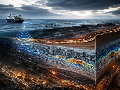
Predicting tsunamis starts at their origin: the ocean floor. High-resolution mapping of submarine topography, or bathymetry, provides the essential boundary conditions for accurate simulations. Subduction zones, where tectonic plates converge, produce most destructive tsunamis, and multibeam echo sounders reveal the detailed geometry of fault lines, enabling modeling of potential displacement scenarios.
The connection between seafloor deformation and wave propagation is governed by complex fluid dynamics. Accurate bathymetric grids translate these theoretical equations into practical hazard assessments for coastal regions. Modern surveys employ autonomous underwater vehicles to explore remote trench systems, delivering centimeter-scale vertical accuracy, a significant improvement over older satellite datasets that often overlooked subtle yet seismically critical features.
During a megathrust earthquake, initial seafloor uplift or subsidence determines the tsunami’s starting waveform. Assessing submarine landslide risk, another major hazard, requires detailed geotechnical mapping of continental slopes, which together inform early warning systems and coastal preparedness strategies.
Bathymetry’s Critical Role
Bathymetric data form the essential foundation for tsunami forecasting, as uncharted underwater canyons and seamounts can cause significant errors in predicted arrival times and wave heights. Agencies like the National Oceanic and Atmospheric Administration maintain seamless bathymetric-topographic digital elevation models for coastal areas, enabling high-fidelity simulations of waves transitioning from deep ocean to inundating bore. These datasets support the development of scenario-based hazard maps, which engineers and urban planners use to design evacuation routes and critical infrastructure, ensuring that resilience measures are evidence‑based.
To operationalize mapping data, scientists employ a range of technologies and analytical methods. The following approaches represent the current standard for integrating seafloor information into early warning systems:
- 🛰️ Satellite altimetry – provides broad, low-resolution gravity anomalies to identify major tectonic structures.
- 🚢 Shipboard multibeam sonar – yields high-resolution swath mapping for targeted subduction zone segments.
- 🌊 Seafloor geodesy (pressure sensors & acoustic ranging) – measures real-time deformation to detect precursory slip.
- 🤖 Machine learning inversion – rapidly translates real-time seafloor deformation data into source models for tsunami generation.
Recent advances in autonomous surface vessels have dramatically accelerated the collection of bathymetry in remote ocean regions. These uncrewed systems can remain on station for months, systematically filling data voids that historically hindered forecast accuracy.
Integrating bathymetric data with dense offshore observation networks creates a feedback loop for model improvement. Each event provides new calibration points, allowing researchers to refine the Green’s function libraries that underpin rapid tsunami source inversion.
The 2004 Sumatra-Andaman Wake-Up Call
The December 2004 earthquake highlighted the lethal consequences of incomplete seafloor knowledge. The rupture spanned over 1,300 kilometers of uncharted subduction zone, generating a tsunami that claimed nearly 230,000 lives across the Indian Ocean. Post-event surveys showed that existing bathymetric maps lacked the resolution to capture the complex geometry of the Sunda megathrust, and multibeam swath mapping conducted afterward revealed the segmented nature of the fault, explaining why the rupture extended farther than initial seismological models predicted.
The disaster prompted a global shift in prioritizing ocean mapping for hazard mitigation, with international initiatives aiming to chart remaining uncharted subduction zones within a generation. Reanalysis of the 2004 event using modern bathymetric data fundamentally improved understanding of tsunami mechanics, showing that a slow, shallow slip component—undetectable by traditional seismic networks—significantly amplified seafloor displacement and wave heights, underscoring bathymetry as a global public good.
These findings established that tsunami potential cannot be inferred from earthquake magnitude alone. Accurate forecasting requires detailed knowledge of seafloor structure and the ability to model heterogeneous slip, a principle now embedded in operational early-warning protocols worldwide.
Sensing the Silent Threat
Not all tsunamigenic events begin with a detectable earthquake. Submarine landslides and slow-slip transients can displace water silently, creating cryptic hazards. Advanced seafloor mapping combined with cabled observatories now provides continuous monitoring, with acoustic arrays and differential pressure gauges detecting centimeter-scale deformation on submerged slopes, offering early warnings for potential failures. The 1998 Papua New Guinea tsunami illustrates this risk, where a modest earthquake triggered a submarine landslide that produced waves far exceeding seismic-based predictions, later confirmed through high-resolution bathymetry.
Contemporary risk frameworks integrate geotechnical slope stability models with ultra-high-resolution bathymetry to identify zones prone to failure. This methodology allows hazard mappers to generate probabilistic landslide tsunami scenarios, complementing earthquake-driven forecasts and enhancing early-warning and preparedness strategies.
Real-Time Tsunami Intelligence
Operational tsunami warning centers now ingest bathymetric data in real time, transforming static maps into dynamic decision-support tools. The integration of seafloor observations with seismic networks and deep-ocean pressure sensors creates a comprehensive monitoring ecosystem.
When an earthquake occurs, automated systems retrieve precomputed tsunami propagation libraries derived from high‑resolution bathymetry. These libraries, built from thousands of scenario simulations, reduce forecast latency from hours to minutes, a critical window for coastal protection.
The accuracy of these rapid forecasts hinges entirely on the fidelity of the underlying bathymetric grid. A 2023 intercomparison study demonstrated that upgrading from 30‑arcsecond to 3‑arcsecond resolution reduced arrival time errors by more than forty percent for complex coastlines with intricate offshore canyon systems.
Warning center scientists employ a structured workflow to translate raw seafloor data into actionable alerts. The key stages of this process are outlined below:
| Process | Timing / Status | Description |
|---|---|---|
| Data assimilation | real‑time | merging DART buoy readings with precomputed bathymetric models. |
| Source inversion | 2‑4 min | determining slip distribution from seafloor geodesy and seismic waveforms. |
| Ensemble forecasting | uncertainty | running multiple scenarios to capture bathymetric data gaps. |
| Product dissemination | automated | delivering polygon‑based warnings to emergency managers. |
Advancements in machine learning now enable probabilistic source characterization directly from real‑time bathymetric deformation arrays. These algorithms, trained on thousands of simulated rupture scenarios, produce confidence intervals for wave heights that rival traditional ensemble methods at a fraction of the computational cost.
Overcoming Depth and Distance
Mapping the seafloor at tsunamigenic scales presents formidable technical challenges, particularly in the abyssal plains and hadal trenches where most great earthquakes occur. The combination of extreme pressure, remote logistics, and vast spatial extent requires innovative technological solutions.
Autonomous surface vehicles equipped with multibeam echosounders now systematically survey remote subduction zones previously inaccessible to crewed vessels. These platforms operate for months, transmitting processed bathymetric data via satellite to continually update global digital elevation models.
International collaboration through initiatives like the Seabed 2030 project has accelerated the acquisition of critical bathymetric data in the Pacific Ring of Fire. The following table summarizes key technological approaches and their respective contributions to tsunami prediction capabilities:
| Technology | Operating Depth | Primary Contribution to Tsunami Prediction |
|---|---|---|
| Satellite gravimetry | Global coverage | Identifies major tectonic structures in unmapped regions |
| Shipboard multibeam | Full ocean depth | Provides high‑resolution fault geometry for source modeling |
| AUV‑based interferometric sonar | < 6,000 m | Delivers centimeter‑scale slope stability assessments |
| Seafloor geodesy arrays | Plate boundary zones | Enables direct measurement of slow slip and tsunami precursors |
A persistent challenge remains the resolution gap between deep‑ocean bathymetry and coastal nearshore topography. Seamless integration across this transition zone is essential for modeling wave shoaling and inundation accurately, requiring sub‑meter coastal lidar to complement offshore sonar data.
Emerging distributed acoustic sensing technology leverages existing submarine telecommunication cables as dense arrays of virtual seismometers. This innovation transforms communication infrastructure into a continuous bathymetric and deformation monitoring network, dramatically expanding observational coverage in data‑sparse regions.