Seeing the Unseen: The GPR Technology
Ground Penetrating Radar (GPR) has fundamentally altered the trajectory of urban archaeological prospection. This non-invasive geophysical method allows researchers to visualize buried structures without the need for extensive excavation, preserving the stratigraphic integrity of a site for future generations.
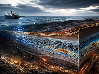
The core principle involves transmitting high-frequency electromagnetic pulses into the ground from a surface antenna. When these pulses encounter subsurface materials with different electrical properties, such as a buried wall contrasting with surrounding soil, part of the energy is reflected back to the surface and recorded by a receiving antenna.
The recorded signal, or waveform, is a function of the time it takes for the pulse to travel down, reflect, and return. This two-way travel time is then converted into an estimated depth, creating a continuous profile of the subsurface as the antenna is moved along a transect. By systematically collecting hundreds of these parallel profiles, sophisticated software can compile the data into a three-dimensional model of the buried landscape. This reveals not only the location of architectural features like foundations and roads but also the presence of voids, burial pits, and even changes in soil stratigraphy that indicate past human activity. The technology effectively provides a virtual window into the earth, allowing archaeologists to target their excavations with unprecedented precision and to study large urban areas in their entirety for the first time.
How Does It See Beneath the Surface?
The effectiveness of GPR in urban environments hinges on the contrast in dielectric permittivity between buried archaeological features and the surrounding matrix. A stone wall, for instance, holds less water than the soil around it, creating a distinct electrical boundary that strongly reflects the radar wave. This physical principle allows the instrument to distinguish between subtle variations in material composition.
The selection of the appropriate antenna frequency is a critical methodological decision. Lower frequencies, such as 100-200 MHz, offer greater penetration depth, sometimes reaching up to ten meters or more, but at the cost of lower resolution. Conversely, higher frequencies, like 500-900 MHz, provide exquisite detail of shallow features but have a limited depth of investigation, often less than three meters in conductive soils. Archaeologists must therefore balance depth of exploration with the desired resolution for their specific research questions.
Before commencing a survey, a grid system is established over the site using total stations or GPS. The GPR operator then pulls the antenna along closely spaced lines within this grid, often at intervals of 0.5 meters or less. The instrument records a vast amount of data, storing each radar trace digitally. This raw data requires significant post-processing to remove noise, filter out extraneous signals from modern utilities, and correct for topographical variations. The final product, after this computational enhancement, is a depth slice or time-slice map, which presents a horizontal view of the subsurface at specific depths, enabling archaeologists to visualize the complete footprint of a buried structure or an entire ancient neighborhood plan.
To illustrate the relationship between antenna frequency and survey objectives, consider the following typical applications:
| Antenna Frequency | Typical Depth | Optimal Target Features |
|---|---|---|
| Low (100-200 MHz) | 5-15 meters | Deep foundations, large cavities, bedrock topography |
| Medium (250-500 MHz) | 2-5 meters | Walls, floors, large tombs, street layouts |
| High (500-1000 MHz) | <1-2 meters | Buried artifacts, small pits, plaster floors, detail in stratigraphy |
The raw data collected in the field manifests as a radargram, a two-dimensional image that plots reflections against depth. Interpreting these images requires specialized training and experience, as natural reflections from tree roots or animal burrows can mimic archaeological features. The creation of amplitude maps, which measure the strength of reflected energy across the grid at specific depths, is a key analytical step for identifying coherent structures.
From Data to Discovery: Interpreting the Signals
The transformation of raw GPR data into archaeological knowledge relies on sophisticated signal processing and interpretative frameworks. Specialized software filters out background noise and migrates the data, a process that corrects the position of dipping reflections to their true subsurface locations, thereby clarifying the geometry of buried features.
One of the primary interpretative tools is the creation of amplitude time-slices. These horizontal maps integrate reflected energy from a specified depth range, allowing researchers to visualize the plan view of archaeological features. High-amplitude anomalies often indicate substantial contrasts, such as compacted floors or stone foundations, while voids may produce distinctive diffraction patterns known as reflection hyperbolas in the vertical radar profiles.
The differentiation between anthropogenic features and natural soil variations presents a constant challenge. Modern utility lines, root systems, and animal burrows can generate reflections that superficially resemble ancient walls or pits. Archaeologists mmust therefore integrate GPR results with other datasets, including historical maps, aerial photographs, and surface artifact distributions, to build a coherent and contextually informed interpretation of the buried landscape.
To navigate the complexities of subsurface interpretation, analysts often categorize the types of reflections observed in the data. A systematic approach to classifying these anomalies is essential for distinguishing between cultural features and natural phenomena.
| Reflection Type | Typical Cause | Archaeological Interpretation |
|---|---|---|
| Planar, high-amplitude | Dense, uniform material | Floors, paved surfaces, compacted roads |
| Linear, high-amplitude | Vertical interfaces | Wall foundations, ditch edges, defensive ramparts |
| Point-source hyperbolas | Discrete objects | Buried artifacts, pillars, large stones, utilities |
| Chaotic, low-amplitude | Heterogeneous fill | Collapsed rubble, backfilled pits, midden deposits |
The final and most crucial step in this analytical chain is ground-truthing through targeted excavation. By excavating small trenches over representative anomalies, archaeologists verify the geophysical interpretation and calibrate their understanding of how specific feature types manifest in the GPR data. This iterative process, where excavation refines interpretation, continuously improves the accuracy of non-invasive surveys and builds a more reliable foundation for understanding the spatial organization of ancient cities.
The interpretative process is further complicated by the heterogeneous nature of urban stratigraphy. However, several guiding principles assist in distinguishing meaningful patterns from background clutter.
- Spatial context is paramount; isolated anomalies are less compelling than those forming rectilinear patterns indicative of architecture.
- Depth continuity between adjacent time-slices helps confirm that a feature is structural and not a superficial disturbance.
- The strength of the reflected signal must be evaluated relative to the surrounding matrix to assess feature integrity.
- Integration with excavation data creates a feedback loop, allowing for the refinement of geophysical models for future surveys in similar environments.
A New View of Pompeii and Herculaneum
The Roman cities of Pompeii and Herculaneum, buried by the eruption of Mount Vesuvius in 79 CE, have been transformed from fragmented excavation sites into comprehensively understood urban landscapes through extensive GPR surveys. These investigations have penetrated the deep volcanic deposits, revealing the complete street grid and insula blocks that were previously only partially known.
In previously unexcavated areas of Pompeii's Regio V, GPR has identified the complete floor plans of numerous houses, shops, and workshops. The technology detected not only robust stone foundations but also the compacted earthen floors of poorer dwellings and commercial spaces, providing a more socially inclusive picture of the city's population than was available from the richly decorated houses alone. The identification of a previously unknown bakery with its millstones still in situ exemplifies the method's power to reveal details of economic life.
To appreciate the range of features brought to light beneath the volcanic debris, consider the following discoveries made possible by GPR.
| Feature Type | Example Location | Archaeological Significance |
|---|---|---|
| Elite Dwellings | Regio V, Pompeii | Complete atria and peristyle gardens mapped in plan |
| Commercial Buildings | Along Decumanus Maximus | Tabernae (shops) with rear courtyards identified |
| Infrastructure | Suburban areas | Water distribution systems and drainage channels located |
| Public Spaces | Herculaneum's waterfront | Vaulted chambers and possible warehouses detected |
At Herculaneum, GPR surveys along the ancient coastline have mapped the extent of the buried beach and the structures that lined it, areas too deep for conventional excavation. This work has revealed the complete plan of vaulted chambers that once served as boat sheds or warehouses, fundamentally altering interpretations of the city's relationship with the sea. These non-invasive maps allow researchers to pose new research questions about urban infrastructure, social zoning, and economic networks across the entire urban fabric, not just in the areas cleared for public viewing.
The insights gained from these Vesuvian sites extend beyond individual buildings to address broader questions of Roman urbanism. The GPR data has enabled the creation of high-resolution digital elevation models of the pre-79 CE topography, showing how the natural landscape was modified to accommodate the expanding city. This holistic view confirms that urban development was a planned and engineered process, with streets laid out to manage drinage and public buildings positioned to dominate the visual landscape. The integration of geophysical and excavated data thus provides an unprecedented, multi-dimensional understanding of daily life, social organization, and urban evolution in these iconic Roman towns.
Revealing Daily Life in the Maya Lowlands
GPR applications in the Maya Lowlands face distinct challenges due to the humid tropical environment. The conductive clay-rich soils rapidly attenuate radar energy, limiting penetration depths compared to the volcanic contexts of Pompeii.
Despite these geophysical obstacles, surveys have successfully mapped extensive water management systems essential to Maya urbanism. These discoveries include the remnants of reservoirs, canals, and modified drainage patterns that sustained large populations.
More recent GPR studies focus on residential zones beyond the monumental cores, revealing the organization of household groups and domestic production areas. By identifying the floor plans of commoner dwellings and associated agricultural terraces, archaeologists are constructing a more nuanced picture of daily life that balances the traditional narrative centered on elite rulers and their ceremonial centers. This shift towards household archaeology is fundamentally altering our understanding of ancient Maya social and economic structures.
The Next Era of Urban Archaeology
The trajectory of urban archaeology is being reshaped by advancements in artificial intelligence and machine learning algorithms. These tools are increasingly capable of automating the detection of hyperbolic reflections and linear features within massive GPR datasets, drastically reducing processing time and enhancing the objectivity of interpretations.
Integration of GPR with other non-invasive methods, such as magnetometry and electrical resistivity tomography, is becoming standard practice. This multi-sensor approach provides complementary datasets, where magnetic anomalies might indicate fired features like kilns, while GPR reveals their structural context. The fusion of these data streams within geographic information systems allows for a more holistic characterization of buried urban environments.
Mobile GPR arrays, towed by vehicles or mounted on robotic platforms, are accelerating survey speeds dramatically. This technological leap enables the mapping of entire ancient cities at unprecedented scales, moving from site-specific studies to landscape-level urban analyses.
Perhaps the most profound future development lies in the integration of real-time visualization and on-site interpretation. As computational power increases, archaeologists will be able to generate and interpret depth-slice images directly in the field, allowing for adaptive survey strategies that target emerging patterns. This shift positions GPR not merely as a prospection tool but as a fundamental component of a ethical and professional responsibility to document and preserve the finite archaeological record for future generations, ensuring that non-invasive exploration becomes the first, and often most crucial, step in any urban archaeological investigation.