The Evolution of Atmospheric Science
The transformation of weather prediction from a practice rooted in folklore and empirical observation to a rigorous scientific discipline represents a fundamental leap in human capability. Early attempts relied on pattern recognition and natural indicators, which were inherently localized and unreliable for anything beyond very short-term extrapolation. The establishment of meteorology as a formal science introduced a systematic and physically-grounded framework for understanding atmospheric phenomena.
This scientific revolution was catalyzed by pivotal technological innovations, such as the invention of the barometer and thermometer, which allowed for the quantification of atmospheric state variables. Concurrently, the formulation of key physical laws, including the gas laws and the laws of thermodynamics, provided the essential theoretical bedrock. This transition marked a shift from qualitative guesswork to a quantitative and physically-based understanding, enabling the development of predictive models rather than mere descriptive summaries of past weather.
Core Atmospheric Physics
At the heart of modern forecasting lies a deep understanding of atmospheric physics, primarily governed by thermodynamics and fluid dynamics. These principles dictate how energy is transferred, how air masses behave, and how precipitation forms. The accurate prediction of cloud development, storm intensity, and temperature advection is impossible without applying these fundamental laws.
Thermodynamic processes, such as adiabatic cooling and latent heat release, are critical for modeling convective activity and severe weather. Fluid dynamics, expressed through the governing equations of fluid motion, explains the genertion of wind, the evolution of pressure systems, and the transfer of momentum across different scales. Mastery of this complex interplay between thermal and dynamic forces is non-negotiable for skillful prediction.
The application of these principles requires solving the Navier-Stokes equations for a compressible fluid on a rotating sphere—a formidable mathematical challenge. Simplifications like the hydrostatic approximation and parameterizations for sub-grid-scale processes (e.g., turbulence, cloud microphysics) are necessary to make the problem computationally tractable. This intricate physical foundation directly translates into the fidelity of numerical weather prediction models, where errors in representing core physics cascade into significant forecast inaccuracies.
| Physical Law/Principle | Primary Atmospheric Variable Affected | Direct Forecasting Impact |
|---|---|---|
| Ideal Gas Law | Pressure, Temperature, Density | Initial analysis of air masses, pressure gradient force calculation |
| First Law of Thermodynamics | Temperature, Internal Energy | Predicting temperature changes from compression/expansion, diabatic heating |
| Conservation of Momentum (Navier-Stokes) | Wind Velocity, Vorticity | Simulating wind fields, jet streams, and cyclone development |
| Clausius-Clapeyron Relation | Water Vapor Content, Saturation | Quantifying precipitation potential and maximum humidity levels |
- Thermodynamic Energy Transfer: Governs temperature changes via adiabatic processes and latent heat exchange during phase changes of water.
- Fluid Dynamical Motion: Describes the movement of air parcels subject to pressure gradients, Coriolis force, and friction.
- Radiative Transfer: Determines heating rates from solar insolation and terrestrial infrared emission, crucial for diurnal cycles and climate.
- Cloud Microphysics: Parameterizes the formation and interaction of cloud droplets, ice crystals, and precipitation particles.
Global Circulation Patterns
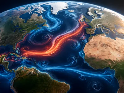
The atmosphere is not a chaotic system but one organized into semi-permanent, large-scale circulation patterns that govern the general transfer of heat and momentum from the tropics to the poles. Understanding these patterns, such as the Hadley, Ferrel, and Polar cells, is essential for predicting the prevailing tracks of mid-latitude storms, the positioning of subtropical high-pressure zones, and the behavior of the jet streams that act as atmospheric steering currents. These patterns explain the climatic predisposition of regions to aridity or rainfall, forming the background state upon which daily weather systems evolve.
Forecast models must accurately initialize and simulate the strength and position of features like the Intertropical Convergence Zone (ITCZ) and the Rossby wave patterns in the upper troposphere. Errors in representing these large-scale flows lead to significant downstream forecast drift, as they modulate the development, movement, and decay of synoptic-scale weather systems. The non-linear interactions between these planetary waves and smaller-scale phenomena are a primary focus of dynamical meteorology, as they are responsible for regime changes and the onset of high-impact weather events, such as blocking patterns that can cause prolonged heatwaves or cold spells across continents.
| Circulation Pattern | Primary Driver | Key Forecasting Role |
|---|---|---|
| Hadley Cell | Thermal convection at equator | Defines trade winds, subtropical jet, and arid zones. |
| Ferrel Cell | Eddy-driven mid-latitude circulation | Governs westerly wind belt and storm track variability. |
| Polar Cell | Radiative cooling at poles | Influences polar front position and Arctic oscillation. |
| Walker Circulation | Zonal sea surface temperature gradients | Core of ENSO, dictates tropical Pacific climate anomalies. |
- Jet Streams: High-altitude, narrow air currents that steer weather systems and demarcate air masses.
- Rossby Waves: Planetary-scale meanders in the westerlies that influence cyclone development and blocking events.
- Monsoon Circulations: Seasonal reversals of wind driven by land-sea thermal contrasts, crucial for regional precipitation.
- Ocean-Atmosphere Coupling: Interactions, as seen in ENSO, that force predictable seasonal climate teleconnections.
Modern Observational Networks
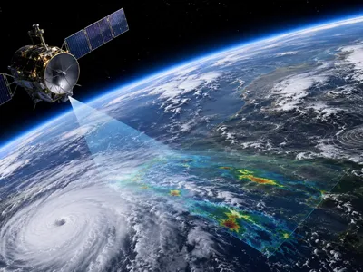
The predictive skill of meteorological models is fundamentally constrained by the quality and density of initial observational data. Data assimilation is the sophisticated process of integrating heterogeneous observations from a global network into a physically consistent model state. This network is a multi-platform system, comprising in-situ and remote sensing instruments.
Satellites provide critical continuous coverage, measuring radiances from which temperature, humidity, cloud properties, and wind vectors are derived. Radar networks offer high-resolution, three-dimensional data on precipitation intensity, storm structure, and wind fields, vital for nowcasting and initializing convective-scale models.
Complementing these are automated surface weather stations, radiosondes (weather balloons), aircraft-based sensors (AMDAR), and buoy networks over oceans. Each platform has unique strengths and limitations in spattial coverage, resolution, and the specific variables observed. The synergistic use of all these data sources through advanced data assimilation algorithms creates a comprehensive four-dimensional snapshot of the global atmosphere, which is the indispensable starting point for any numerical forecast.
| Observation Platform | Key Parameters Measured | Primary Contribution to Forecast |
|---|---|---|
| Polar-Orbiting & Geostationary Satellites | Temperature profiles, water vapor, cloud-top pressure, sea surface temperature, atmospheric motion vectors. | Global coverage, essential for data-sparse regions (oceans, poles), model initialization. |
| Weather Radar (Doppler, Dual-Pol) | Precipitation rate, storm reflectivity, radial velocity, hydrometeor classification. | Mesoscale analysis, short-term storm forecasting, flash flood guidance. |
| Radiosonde Network | High-vertical-resolution profiles of pressure, temperature, humidity, wind. | Upper-air truth for model validation and calibration, critical for analysis. |
| Automated Surface Stations & Buoys | Surface pressure, temperature, wind, humidity, precipitation. | High-temporal resolution data for boundary layer processes and model verification. |
- Data Assimilation: The mathematical process of optimally blending observations with a prior model forecast to produce the best possible initial conditions.
- Remote Sensing: Enables the measurement of atmospheric properties from a distance, crucial for global coverage.
- Synoptic Scale Observations: Provide the fundamental data for analyzing and predicting large-scale weather systems.
- High-Frequency Mesonet Data: Supports very short-range forecasting and severe weather warnings.
The Power of Computer Models
Numerical Weather Prediction (NWP) represents the cornerstone of modern forecasting, transforming atmospheric physics into a solvable mathematical framework. By discretizing the governing equations of fluid dynamics and thermodynamics over a three-dimensional global grid, NWP models simulate the future state of the atmosphere through iterative time steps. The computational expense of these simulations is monumental, requiring supercomputing clusters to achieve the necessary resolution and timeliness for operational use.
The evolution of model fidelity is directly tied to advances in computational power and algorithmic efficiency. Early barotropic models, which simplified the atmosphere to a single layer, have given way to fully coupled, non-hydrostatic global models that explicitly resolve convective processes and intricate cloud interactions. Key advancements include increased spatial resolution, which reduces errors in representing complex topography and land-sea contrasts, and improved physical parameterizations for sub-grid scale phenomena like turbulence, radiation, and moist processes. The transition from spectral to grid-point methods and the implementation of adaptive mesh refinement techniques have further enhanced the accuracy of simulating multi-scale interactions, from global Rossby waves to mesoscale convective systems.
The core of an NWP system is its dynamical core, which must maintain numerical stability while conserving critical properties like mass, energy, and potential vorticity. Modern global circulation models (GCMs) and limited-area models (LAMs) employ sophisticated data assimilation techniques, such as four-dimensional variational (4D-Var) or ensemble Kalman filter (EnKF) methods, to initialize from the observed state. The continuous cycle of assimilation, forecast, and verification creates a self-improving system where model biases are systematically identified and reduced. This relentless refinement, driven by both better physics and more powerful computation, has extended skillful forecast lead times by approximately one day per decade, a remarkable testament to the synergy between meteorology and computer science.
Forecasting and Managing Uncertainty
Deterministic weather forecasting, which produces a single "best guess" prediction, inherently underestimates the chaotic nature of atmospheric dynamics. The realization of sensitive dependence on initial conditions within nonlinear systems necessitated a paradigm shift toward probabilistic forecasting. This approach explicitly quantifies the uncertainty inherent in any prediction, providing forecasters and end-users with crucial information about forecast confidence and alternative scenarios.
Ensemble prediction systems (EPS) are the primary tool for this task, running multiple model simulations from slightly perturbed initial conditions and/or with variations in model physics. The spread of the resulting "ensemble" of forecasts indicates the predictability of the atmospheric flow for a given situation. A tightly clustred ensemble suggests high confidence, while a wide divergence signals low predictability and increased risk of forecast error. Advanced post-processing of ensemble output, including statistical calibration and the generation of probability density functions, transforms raw model data into actionable probabilistic guidance for parameters like temperature, precipitation, and severe weather indices.
The operational utility of ensemble systems is immense. They enable the calculation of probabilities of exceedance for critical thresholds (e.g., flood levels, hurricane intensity) and the identification of high-impact, low-probability events that might be missed in a deterministic run. Furthermore, ensemble techniques are fundamental to sub-seasonal to seasonal (S2S) prediction, where internal atmospheric variability dominates over boundary forcing. By sampling the range of possible future states, EPS provides essential risk-based decision-support for sectors including agriculture, energy, transportation, and emergency management, moving beyond "what the weather will be" to "what the weather might be and with what likelihood."
Future Frontiers in Prediction
The trajectory of weather prediction is now being fundamentally reshaped by the integration of artificial intelligence and machine learning (AI/ML) techniques. These data-driven approaches are moving beyond post-processing applications to the core of model emulation and pattern recognition. AI models can identify complexx, non-linear relationships in vast observational and model datasets that may be opaque to traditional physical parameterizations, offering the potential for significant acceleration of forecast models and the discovery of novel predictive signals, especially in challenging regimes like convective initiation or sub-seasonal variability.
Concurrently, the drive toward kilometer-scale global modeling aims to explicitly resolve deep convective processes and complex terrain interactions, thereby reducing reliance on the most uncertain parameterizations. This grand challenge requires exascale computing and novel algorithmic approaches to manage the immense data throughput and energy consumption. The scientific promise is a more seamless prediction system where the artificial boundary between weather and climate models dissolves, enabling detailed projections of how high-impact weather statistics may evolve in a changing climate. This convergence of scale addresses critical gaps in predicting localized extreme events.
The ultimate frontier is the development of a fully integrated Earth System Prediction capability. This paradigm extends beyond the atmosphere to rigorously couple dynamic models of the ocean, sea ice, land surface (including hydrology and vegetation), and atmospheric composition. Such a holistic framework is essential for skillfully predicting phenomena with long memory and cross-domain interactions, such as multi-year droughts, tropical cyclone genesis modulated by upper-ocean heat content, or the influence of soil moisture anomalies on heatwave persistence. The scientific and computational complexity is staggering, but it represents the necessary evolution to meet societal demands for environmental intelligence across timescales from hours to decades, fundamentally transforming weather prediction into comprehensive environmental prediction.
- Artificial Intelligence Integration: Hybrid AI-physical models and pure ML emulators for accelerated forecasting and enhanced pattern detection in high-dimensional data.
- Exascale and Kilometer-Scale Modeling: Global storm-resolving models that explicitly simulate convective systems, requiring next-generation supercomputing architectures.
- Seamless Prediction Across Timescales: Unified modeling frameworks that bridge weather, sub-seasonal, seasonal, and climate prediction, removing artificial boundaries.
- Earth System Prediction Capability: Tightly coupled models of atmosphere, ocean, land, ice, and aerosols to predict cross-domain interactions and compound events.
- Digital Twins of the Earth: Ultra-high-fidelity, continuously updated simulation environments for scenario testing and policy support.